SSCI-581-Week5
Land Use and Mapping Population
Definition of Land Tenure
- In simple terms, land tenure systems determine who can use what resources, for how long, and under what conditions.
Categories of Land Tenure
- Private : Held by a private party, which could be an individual, corporate body, married couple, etc.
- Communal: Held by a community in which each member has the right to independently use land
- Open access: No right are assigned to anyone and no one can be excluded
- State: A governmental or other public authority holds rights.
Land Administration
- How land tenure and associated property rights are operationalized
- In developed countries, involves an extensive array of systems and institutions
- In less developed countries, is many times informally administered.
Public Land Survey System (PLSS)
- US system for administering the transfer and sale of public lands to private parties following the Revolutionary War
- After US gained independence, the federal government wanted to reward soldiers for service and raise money for the new nation
- Before this could happen, a way to partition the land had to be quickly devised
Why do we still use the PLSS
- Roads and property lines have been aligned to sections of land
- Federal and state land administrations are subject to the boundaries of the PLSS
- Private landowner records are tied to the system
- BLM ensuring GIS data of the PLSS complies with FGDC guidelines
Population Data
Why Map People
- To study effect of population, topography, and housing on mortality
- Different geographies (ward, neighborhood, district) used
- Problem: district boundaries change and geographic framework changes
Census Spatial Data
- Census data contains two types of flies:
- Spatial boundaries (without population information)
- Population information (spreadsheets; NOT spatial)
Land Use
- Land Cover describes what is physical on the land
- Land Use describes how people use the land
- Zoning is a spatial, legal framework for how people are permitted to use the land (but not necessarily how it is actually being used)
Dasymetric Mapping
- Redistributing quantities (population) through areal interpolation using selected variables and ancillary data
- Essence: combining census data with land use data (of your choices)
Population Mapping Key Points
- Land Administration (property rights, ownership, taxation) is separate from how populations are mapped, but can play a role given land use
- Important to know the geographies of people to study the impacts of X on people and place
- Most aggregations can be problematic for one reason or another
- One solution is to map population data combined with additional data to tell us where people are not
- Gridded population does not solve all MAUP of mapping populations
The Roles of Tables
Databases and Spatial Databases
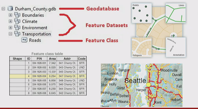
- A database is an organized collection of data in a digital environment
- A spatial database is designed to optimally store spatial data, and can also store aspatial data

Geodatabase elements

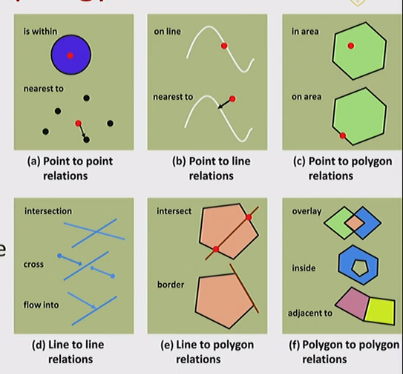
Topology
- Topology is the spatial relationships among a data features and sets
- There are many different ways to define and enforce spatial relationship rules
- Examples: adjacent polygons have shared edges; no gaps between polygons; lines can either share segments or not; lines can share nodes and points can be nested within lines, etc.

Attribute Tables
Attribute Types in .gdb
- Numbers: Can be one of four numeric data types: short integers, long integers, single-precision floating-point numbers, and double-precision floating-point numbers
- Text: Any set of alphanumeric characters of a certain length
- Date: Holds date AND time data
- BLOBs: Binary large objects are used to store and manage binary information such as symbols andCAD geometries
- Global identifiers: Global ID and GUID data types store registry style strings consisting of 36 characters enclosed in {}; uniquely identify a feature or table row within a geodatabase and across geodatabases; used to manage relationships especially for data mangement, versioning, change-only updates, and replication
Measurement Attributes
- Attribute type, how it is saved, and the level of measurement if allows: Nominal, Ordinal, Interval, Ration

The Importance of Attribute Tables
- Descriptions, measurements, or classifications of the geographic information on the map
- Tables can be joined to features by a “relationship” (Relational Join)
- Tables of information can be joined to feature s based on spatial reference alone, no need for the common “key” (Spatial Join)
Relationships Between Data Sets in an RDBMS
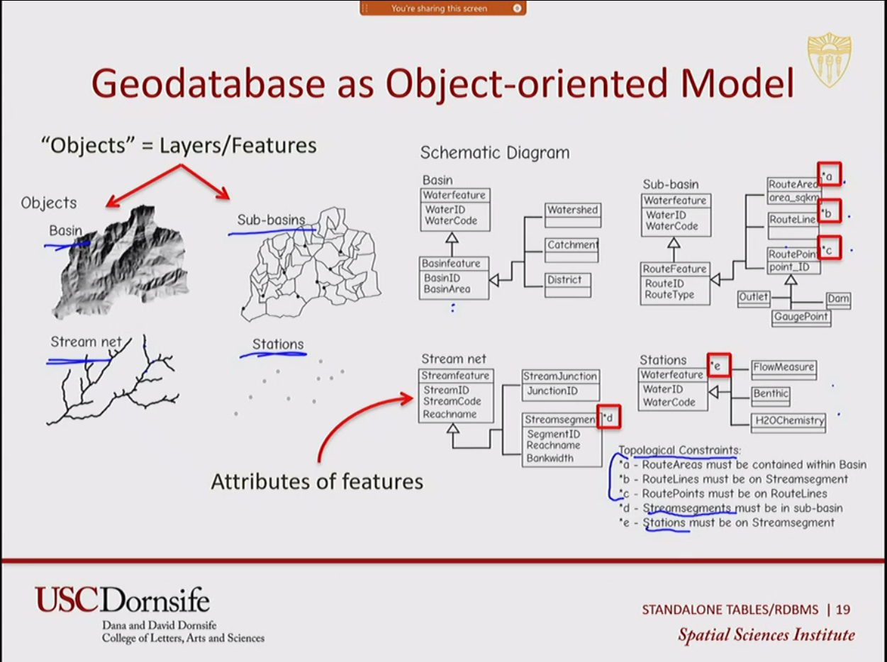
Geodatabse as Obhject-oriented Model

Relational Database and Tables
- Tables in a relational database design show the relations
- Tables are related through one or more columns that meet certain requirements and may be used to index the rows = keys
- Keys are often assigned with unique number of code
- Three types of relationships between entities: 1:1, 1:Many, Many:Many
Structured Query Language (SQL)
- SQL is a language used to communicate with a data base. SQL lets you access and manipulate databases, spatial or aspatial
Summary
All articles in this blog are licensed under CC BY-NC-SA 4.0 unless stating additionally.
Comment


